Instantly Clean up NULLs in SRTM (Shuttle Radar Topography Mission) DEM Data!
3D Nature announces a free data processing utility for all SRTM (Shuttle Radar Topography Mission) data users, just in time for Christmas! SRTMFill is a fast and easy program for patching NULL-data holes in SRTM DEMs by progressively in-filling from surrounding data, quickly making usable data from unusable DEMs. The basic version of SRTMFill is available free of charge to everyone.
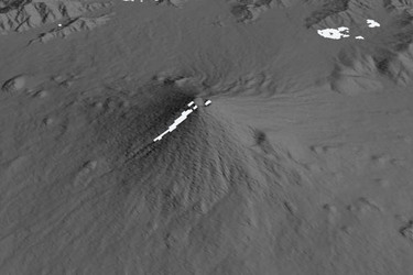
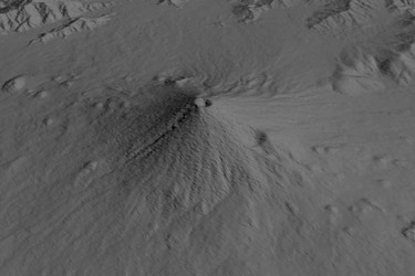
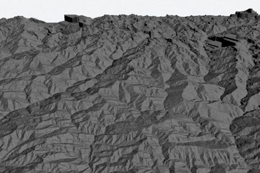
SRTMFill’s simple fast in-fill algorithm can patch moderate-sized NULL holes in flat or sloping terrain. It cannot, however, replace features that are entirely missing, such as putting back an entire mountain. Larges areas of NULL data will be filled with data interpolated from their surrounding edges, which may create unpleasant streaks or platforms in the resulting data. Examples of this situation may be seen in the Everest sample data shown below.
Mount Everest Before
Mount Everest After
Images by Chris Hanson
We do not recommend SRTMFill for extreme cases like these. This process can be acceptable if the area is not the center of attention. If the area of NULL data is in a critical location, we recommend merging the SRTM data with another dataset that may not have missing data in those regions. This could be accomplished using the VNS DEM Merger tool.
Download SRTMFill Now!
SRTMFill.zip for Windows (V1.00, Dec 24, 2003. 58k zip, 128k executable)
Does NOT Require WCS, VNS or any other 3D Nature software. Currently SRTMFill is only available for the Intel/Windows platform.
Any modern computer running a current version of Windows should be able to run SRTMFill.
SRTMFill reads and writes the .hgt file format that SRTM DEMs are currently supplied in. Any software currently able to read these HGT files (such as World Construction Set, Visual Nature Studio or any GIS software) should be able to read the output HGT files created by SRTMFill.
SRTMFill expects the .hgt files to be in the standard 1 arc-second or 3 arc-second tile chunks as provided by the USGS FTP server listed above.
An enhanced version of SRTMFill with multi-file batch capability is intended for those who process a lot of SRTM data, costs $25 . Free licenses of this enhanced version will be made available on request to any current owner of 3D Nature’s World Construction Set 6 or Visual Nature Studio 3 software.