
Visualization for Professionals
Cartography
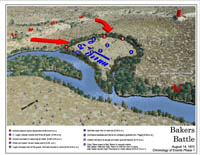
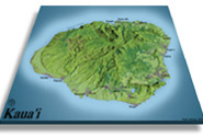
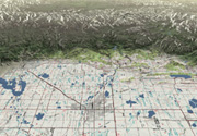
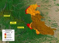
Whether you are creating maps for National Park Visitor Centers, designing fire progression maps for public information, creating topographical maps or making educational materials, 3D Nature provides tools that are designed to be used in many different cartographic applications. Cartographers the world over have chosen WCS and VNS as their tools for creating scientifically and geographically accurate maps.
You’ll probably notice that all of the work on this page varies greatly. All of our tools allow you to express your own style, rather than imposing a certain “look” like so many other programs do. These tools put you in control.
- Take the chore out of cartography with VNS 3’s process improvements and tools. Streamline data flow, reduce file conversion, automate data integration and eliminate redundant changes and updates.
- Use the intuitive and flexible Import Wizard to assimilate your terrain data from over twenty supported formats. Crop, shift, scale, adjust and tile during import. For contour lines, TINs or control points, quickly grid regularized terrain meshes straight from the Import Wizard.
- No need to reproject your data before importing it, VNS natively understands over 30 different projections and over 300 datums. Mix and match data in different projections and datums with ease, VNS will ensure they line up properly. Merge data of different projections, zones, resolutions and qualities to assemble the most effective base map.
- Import landcover and feature information in a variety of CAD and GIS formats. Conform vector boundaries, paths and routes to the terrain. Drape enormous raster images, aerial photos and satellite imagery onto the landscape. Automatically load projection and positioning metadata from industry-standard georeferenced image formats like GeoTIFF and ECW, or plain raster images with World and PRJ files.
- Define vegetated ground cover for realistic presentations, or shaded relief for traditional cartography. Add intelligent color schemes to produce everything from basic hypsographic elevation gradients to sophisticated shaders reacting to elevation, slope, azimuth, convexity/concavity and more. Leverage raster and vector landcover databases to accurately place urban, agricultural and forest textures for maps of astounding detail.
- VNS is not limited in the amount or resolution of terrain it can handle. Create highly-detailed maps of specific areas, regional overviews, even render the entire planet, complete with clouds and stars.
- Plan or Perspective? Choose a Viewpoint interactively, moving the virtual camera around with the mouse. Or, copy from an imported position or path with the Path/Vector Transfer tool. Recreate the view from a GPS-surveyed location. Explore known and unknown vantages. Create plan maps with or without global curvature. Unwrap the Earth by rendering output images in a variety of projections, complete with georeferencing information for use in other cartographic tools. Write plan or perspective documents to Illustrator files with raster shaded terrain overlaid with perfectly aligned vector linework.
- Add lakes and streams, skies and clouds, even 3D buildings and structures. Extrude whole cities of basic 3D buildings just from their overhead footprints. Add Road Components to any path or vector. Use Terraffectors to selectively emphasize topographic features or exaggerate perspective.
- VNS won’t hold you back from creating large high-res output images. Techniques like segmenting and tiling make rendering enormous output manageable. Choose to have VNS assemble the resulting partial renderings into one vast image, or leave them as smaller tiles for convenience or special purposes like multi-page atlases.
- Frequently, several forms or variations of the same basic work are required. Encompassing the numerous variations, ensuring they all stay current to common changes and updating them all when the base data is updated could be a herculean task. Scenarios in VNS coordinate the task of orchestrating multiple variations of a theme within a single easily managed project file. Scenarios can dynamically show or remove elements for a particular rendering. Keep the common elements together as you add or remove features, change lighting conditions, color schemes, switch from photorealistic to stylistic, even present alternative scenarios of the same site.
- Communicate the proposal by choosing the most expressive medium for the project. Create still images, enormous posters, animated fly-throughs and fly-overs, even interact with panoramic renderings showing every angle from one or more viewpoints. Produce everything from a single unified project!
- Exploit existing optional datasets like 3D Nature’s National Land Cover Database CD-ROM and Ultimate Earth DVD-ROM to create high-quality projects depicting the United States, or the entire planet! NLCD contains 30-m raster land cover for the lower 48 States. Ultimate Earth contains 1-km terrain and satellite imagery data for anywhere on the planet!
- Utilize the flexible Post Processing system to add that extra touch to any project. For perspective presentations, adjust real-world controls like exposure, gamma and depth of field. More traditional mapmaking can benefit from applying effects that react to the underlying landscape. Apply a slight blur to low-lying areas to make them appear more distant, enhancing the 3D look of a 2D map. Add colored tints to shadowed areas to recreate popular national styles. Apply more exotic effects like Posterization, Color Maximization or even Cartoon look.
- Creating high resolution posters and detailed animations on a production schedule can tax the computing abilities of the fastest computers. Stay ahead of deadlines by harnessing the power of all available computers with the SuperConductor render farm controller and license-free Render Engine capability included with every VNS. Buy one license of VNS, get the ability to render on many networked clients overnight or on weekends when they’re idle. Deliver more, in less time.
- VNS 3 has many tools to save you time. If you’ve made something useful, chances are you’ll use it again. Minimize redundant work by saving reusable Components for use in future projects. Save color schemes, data sets and output specifications into stand-alone files to integrate into future projects.
- Design your scene and then export it using Scene Express for interactive exploration.
Visual Nature Studio and World Construction Set satisfy the needs of Cartographers at two different levels. Visual Nature Studio gives you greater power, precision and flexibility plus some extra features that WCS doesn’t have. World Construction Set is great for concept development where scientific and geographic accuracy are of lesser importance. Both programs give you the ultimate in artistic expression and photo-realism. If you would like to learn more about the differences between WCS and VNS visit our Product Comparison Page.
If you wish to further discuss how WCS or VNS can work for you please feel free to drop us a note or call our Sales office at (303) 659-4028.
Place an order via our secure web server.