
Visualization for Professionals
Civil Engineering
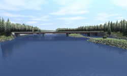
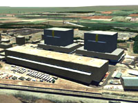
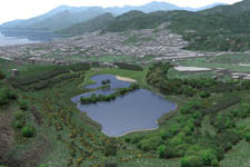
Civil Engineering Experts the world over have chosen WCS and VNS as their tools for visualizing dams, mines, golf courses, neighborhoods and other large construction projects before they are built. You can envision before and after scenes to demonstrate how a project will be portrayed before construction even starts. You are now able to create posters, illustrations and animations with powerful photorealism and GIS accuracy.
- Take the chore out of visualization with VNS 3’s process improvements and tools. Streamline data flow, reduce file conversion, automate data integration and eliminate redundant changes and updates.
- Use the intuitive and flexible Import Wizard to assimilate your terrain data from over twenty supported formats. Crop, shift, scale, adjust and tile during import. Import contour lines or control points from site plan DXF files and quickly grid regularized terrain meshes straight from the Import Wizard. Bring it Together VNS natively understands over 30 different projections including arbitrary local survey systems. Mix and match data in different projections and datums with ease, VNS will ensure your site data lines up properly with commercial airphotos.
- Import road centerlines, structure footprints, excavation and fill perimeters. Attach one of many pre-made Terraffector components to immediately realize dirt or paved roads, complete with texturing, striping, shoulders, ditches, even weeds growing on the margins. Create your own custom Terraffectors specifying the exact desired cross-section profile, texturing and vegetation. Specify allowed cut and fill slopes and distances, as well as materials and appearance.
- Build dams, earthworks and berms, dig mines, quarries, pits, canals, lakes and terraced road cuts. Level building sites and developments, move mountains, split the Earth.Turn on Realtime Terraffector Preview and see the results of your changes immediately as you work, without rendering.
- VNS includes hundreds of specimens of different types of vegetation, ready for planting across the landscape. Use Foliage Effects to plant individual trees in known locations (defined within VNS or imported from site plans). Quickly fill entire areas with plants or trees using Vector-Bounded Ecosystems. Environments and Rules of Nature cover large less-critical outlying areas with a realistic distribution of vegetation using Natural Intelligence to place trees and plants the way nature might. Supplied pre-made Environments capture many typical landcover archetypes found worldwide.
- Drop in buildings, bridges, dams, and other models, complete with realistic texturing. Add vehicles, signs, structures, even people and animals. Quickly set up basic paths for moving objects. Automatically conform rows of utility poles or fence posts to march over hills, and snake around curves. Align large numbers of buildings to automatically face adjacent roads. Add random variations in size, orientation or shape to organic objects to create realistic variations from one design.
- Choose a Viewpoint interactively, moving the virtual camera around with the mouse. Or, copy from an imported position or path with the Path/Vector Transfer tool. Fly down a road centerline. Recreate the view from a GPS-surveyed location. Explore known and unknown vantages. View from overhead, person height or out the window of a proposed structure.
- A visualization is more than just grading and building. Add water bodies like lakes and streams. Make the visualization sing with realistic clouds: puffy, thick, thin, light, dark or colorful. Add fog, mists and distant haze.
- There’s never just one option, and frequently it falls to visualization to depict the multitude of potential courses of action. Encompassing the numerous variations, ensuring they all stay current to common changes and updating them all when the base data is updated could be a herculean task. Scenarios in VNS coordinate the task of orchestrating multiple variations of a theme within a single easily managed project file. Scenarios can dynamically show or remove elements from a visualization for a particular rendering. Keep the common elements together as you add or remove proposed modifications, roads and structures, relocate alterations and redesign proposals, change the lighting and make long-term alterations to the landscape.
- Communicate the proposal by choosing the most expressive medium for the project. Create still images of critical vantage points, large posters contrasting alternatives, animated presentations of before and after, fly-throughs, fly-overs and drive-by movies. Interact with panoramic renderings showing every angle from one or more viewpoints. Depict the same proposal, summer and winter, morning and evening, before and after. Produce everything from a single unified project!
- Add extra defining information to rendered output with Post Processing. The Text and Graphic Overlay features can add the professional finishing touch to every visualization. Add a company logo graphic in one corner of the output. Overlay a copyright notice, or mark not-for-release images as such. The Dynamic Text Overlay feature can put updated constantly changing information about current camera/observer position right onto the animation as a heads-up-display of position, elevation, heading/bearing and more. VNS can automatically annotate each image with the Project name, Camera name and Job/Options name, allowing easy identification of which proposal, variation and viewpoint the image represents.
- Creating high resolution posters and detailed animations on a production schedule can tax the computing abilities of the fastest computers. Stay ahead of deadlines by harnessing the power of all your computers with the SuperConductor render farm controller and license-free Render Engine capability included with every VNS. Buy one license of VNS, get the ability to render on many networked clients overnight or on weekends when they’re idle. Deliver more, in less time.
- VNS 3 has many tools to save you time. When you’ve made something useful, chances are you’ll use it again. Minimize redundant work by saving reusable Components for use in future projects. Open the graphical Component Gallery and browse categories and subcategories of ready-to-use models, vegetation, skies and clouds, everything you need to create compelling visualizations in less time than ever before.
- Design your scene and then export it using Scene Express for interactive realtime exploration.
Visual Nature Studio and World Construction Set satisfy the needs of Civil Engineers at two different levels. Visual Nature Studio gives you greater power, precision and flexibility plus some extra features that WCS doesn’t have. World Construction Set is great for concept development where scientific and geographic accuracy are of lesser importance. Both programs give you the ultimate in artistic expression and photo-realism. If you would like to learn more about the differences between WCS and VNS visit our Product Comparison Page.
If you wish to further discuss how WCS or VNS can work for you please feel free to drop us a note or call our Sales office at (303) 659-4028.
Place an order via our secure web server.