
Visualization for Professionals
Bench Project Visualization, Bighorn National Forest, Sheridan, Wyoming
Computer-aided simulation of our public lands is beneficial to ensure that management activities and constructed facilities fit well into the natural environment. On the Bighorn National Forest in North-Central Wyoming, insect infestation in douglas fir has reached epidemic proportions in the scenic Shell Canyon drainage. Shell Canyon is one of three main transportation corridors crossing the Bighorn mountain range. Douglas fir bark beetle (Dendroctonus pseudotsugae) gained a toehold on the south side the canyon in the aftermath of a small forest fire at the lower (west) end of the canyon. Infestation has been advancing eastward up-canyon at a rate of over one mile per year. The western end of the affected zone is estimated to contain 80% infected trees as of 2005. The east end of the zone is currently 20% infected. It is estimated that mortality will exceed 80% overall without remedial action. The stand is almost exclusively douglas fir with minor components of lodgepole pine, englemann spruce and quaking aspen. The infected zone is bounded above and eastward by colder temperatures less favored by the beetle. Spruce predominates in the canyon bottom forming the northern boundary. The opposing north side of the canyon is naturally unforested providing dramatic views from the highway looking across and down the canyon.
The Forest Service has proposed a timber harvest to remove the infected trees, reduce mortality in the eastern part of the area and regenerate affected stands in either douglas fir, lodgepole pine or aspen. Aware of skepticism among certain public constituencies regarding the necessity and aesthetic desirability of the treatment, 3D Nature was retained to perform a visual simulation of Shell Canyon for use in public forums. The management action being simulated is referred to as the Bench Project by the Forest Service.
Four scenarios were to be visualized: Present conditions; 20 years hence with no management action; 5 years post-treatment and 20 years post-treatment. Panoramic still images were to be generated for each scenario showing the entire five mile long treatment area as it would be seen from a scenic overlook along U.S. Highway 14A on the opposite side of the canyon. In addition animated segments were to be produced to simulate the view from an automobile travelling westward on Highway 14A looking at the treated area. Animations were to be produced for the 5 year post-treatment scenario.
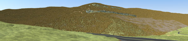
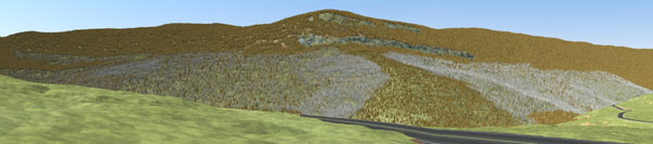
The main focus of the visualization is on the forest where existing variations in land cover must be faithfully represented both inside and outside the treatment area. An existing timber coverage was utilized for outlying areas. In the harvest units additional cruise data was available and deemed most reliable. Polygons were imported to VNS as shape files along with their timber type, height and density attributes. Additional polygons were generated in VNS to represent notable rock outcroppings which were critical to establish the correct sense of place for viewers. Highways and secondary roads were imported as shape files as well. Several temporary roads were also included in the visualization process to determine if they would be visible from key vantage points. These roads will be used in the harvesting operation.
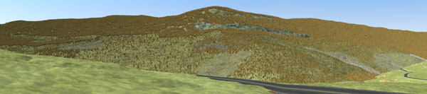
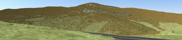
The project was undertaken in March of 2005 and completed on time in that same month. Ecosystems were created to represent the background vegetation layer. Additional ecosystems were defined for each of the harvest treatment prescriptions at both 5 and 20 year conditions. Terraffectors™ were used to depict highways, roads and temporary roads. A generalized ground texture was used for all non-treed areas in the image foreground, the intent being to avoid attracting undue attention away from the forest being studied. Detailed site photographs were used to digitize rock outcroppings in VNS, translating from perspective to plan view “on the fly.” Site photos were also used to validate the Present Conditions simulation, lending added confidence to the “future” simulations in the process. Comparison of site photos to the Present Conditions simulation pointed up one apparent anomaly in the stand cruise data which was corrected in the simulation database to achieve visual compliance with actual on-the-ground conditions.
Visual simulation of the Bench Project will allow both the public and the management agency to see into the future, both with and without forest management activities, to determine if the proposed activities are in the best interest of the public and the public lands themselves.
Videos of a 5-year Post-Treatment Simulation
Visualization within the U.S. Forest Service and the Scenery Management System
“One premise of SMS is that land management activities (including construction of facilities) should not contrast with the existing natural appearing landscape. Within a framework of regional landscape character types, form, line, color, and texture should be used to make activities and structures “fit” within landscapes (Agricultural Handbook 666). This approach promotes a strong response to the context of the natural landscape. It also reinforces the concept of early park planning that structures should be visually subordinate to the landscape.” U.S. Forest Service web site – The Built Environment Image Guide
“Ironically, due to decreased emphasis on the more impactive resource treatments such as clearcut timber harvest methods, the need for this more sophisticated aesthetic resource approach has been questioned. Recent insect and disease disturbances and the reintroduction of fire as an ecosystem management tool may well be catalysts in raising public and management awareness of importance of aesthetics in forest management.” The Scenery Management System: The Evolution of Landscape Aesthetic Management in the U.S. Forest Service abstract by J.S. Bedwell in Proceedings in Landscape and Urban Planning, Vol. 54, Issues 1-4, 25 May 2001.